Aids to approaching competition
The competitive positions of products and services can be assessed with
commercial Data Analysis software like SPSS, SAS and/or completed with
the MULTIVAR program developed
by ourselves. The analysis will use survey data or panels as well as internal
customer databases.
The competitive position of retail outlets needs to be visualised using
a Geographic Information System (GIS) like MapInfo.
We use a geometric triangulation technique in order to link together those
positions in a space (be it perceptual or geographic) that are in direct
competition with each other.
This makes it possible:
- to identify the nearest neighbour (meaning its nearest competitor
for each product/service or for each distribution outlet);
- to compute local competitive intensity indicators as one position's
mean distance to all nearest competitors
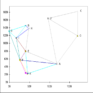 Fig. 1- Using triangulation in order to identify
the nearest neighbour competitor positions
Using geocoding techniques companies should be able to locate their customers
patronage flows using the Geographic Information System (GIS) like MapInfo
on a computer and some of our self programmed procedures in MapBasic language.
Fig. 1- Using triangulation in order to identify
the nearest neighbour competitor positions
Using geocoding techniques companies should be able to locate their customers
patronage flows using the Geographic Information System (GIS) like MapInfo
on a computer and some of our self programmed procedures in MapBasic language.
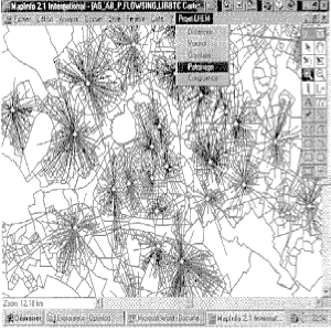 Fig.2 - Proximity patronage customer flows from
census tracts to distribution outlets
Fig.2 - Proximity patronage customer flows from
census tracts to distribution outlets
The study we have done in the North of France offered an interesting
view on travel patterns toward the outlets forming the retail network of
a company. From each census tract customers were patronising an average
of 7 outlets, the number of outlets patronised from each tract varying
from 1 to 39. The 74 outlets situated in this metropolitan area were attracting
people from 5600 census tracts. Each outlet had customers originating from
33 to 1640 census tracts, with an average of 468 census tracts per outlet.
The number of customers visiting each outlet varied from 41 to 16213, with
an average of 3246 customers per outlet.
Although travelling patterns varied a lot some proximity behaviour
could already be observed from initial graphical analysis. Statistical
analysis of the distribution of travelled distances gave a better insight
to patronage behaviour.
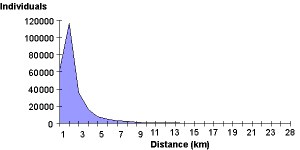 Figure 3. - Distances travelled by individuals
to outlets (km)
Figure 3. - Distances travelled by individuals
to outlets (km)
Figure 3 shows that the majority of the travelled distances is concentrating
towards the minimum in a range which varied between 0 and 28 kilometres.
The average distance travelled by the 254744 customers first analysed was
1,5 km. Nearly three quarters of the customers (70%) travelled less than
2 km and only 10% of the customers travelled more than 4 km.
Performing Cluster Analysis on distribution outlets mean patronage
distance we distinguished three types of outlets proximity outlets (having
the shortest mean patronage distance), central town outlets (with larger
attraction fields) and rural agencies (with the longest patronage distance).
This classification helps to hierarchically subdivide the competitive space
into three levels that can be analysed separately and to which distinct
strategic solutions can be applied.
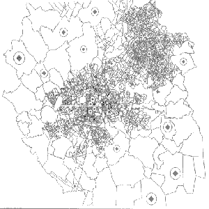 Fig.4 - Using mean customer patronage distance
to distinguish proximity and central town agencies from rural outlets
Partitioning the market area or the perceptual competitive space gives
useful insights of a given competitive situation it helps fixing managerial
objectives and directing marketing efforts and sales force activities.
We suggest two ways of partitioning the market: one that takes only in
account the competitive positions and ignores each product or outlet's
attractiveness and the second that considers attractiveness too.
Fig.4 - Using mean customer patronage distance
to distinguish proximity and central town agencies from rural outlets
Partitioning the market area or the perceptual competitive space gives
useful insights of a given competitive situation it helps fixing managerial
objectives and directing marketing efforts and sales force activities.
We suggest two ways of partitioning the market: one that takes only in
account the competitive positions and ignores each product or outlet's
attractiveness and the second that considers attractiveness too.
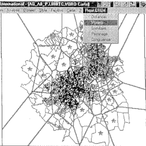 Fig. 5 - Attractiveness insensitive partitioning
of a market
Fig. 5 - Attractiveness insensitive partitioning
of a market
The attractiveness insensitive market partitioning is extremely useful
as a control measure used to evaluate the impact of variable attractiveness
on market penetration
The other way in which we suggest that a positional market can be partitioned
is one taking into account the attractiveness of a position compared to
other positions. We use an Attraction index based on non positional attributes
(like outlet surface, service price, quality etc.).
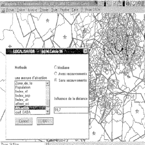 Fig. 6 - Attractiveness sensitive partitioning
of a market
Market partitions normally don't overlap while market areas do. Computing
market areas supposes delimiting the area within which demand points have
a probability superior to a given limit to be attracted by an outlet or
a brand (if the space is the customer's perceptual space).
Fig. 6 - Attractiveness sensitive partitioning
of a market
Market partitions normally don't overlap while market areas do. Computing
market areas supposes delimiting the area within which demand points have
a probability superior to a given limit to be attracted by an outlet or
a brand (if the space is the customer's perceptual space).
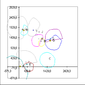
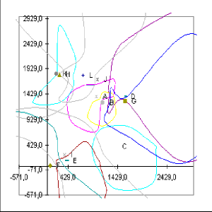 Fig. 7 - Attractiveness sensitive partitioning
of a market
Finding the best location of a new distribution outlet in a distribution
network or finding the position a new product or service should attain
in the perceptual map of the customers, is essential to marketing strategy.
Adapting on recent research (Drezner, 1994) we have operationalised a model
that indicates the optimal location of a new
offer (be it a product, service or retail outlet) in the competitive space
taking into account the firm's and its competitors existing offer as well
as the density of demand points distribution in the analysed space. Besides
the optimal location the model indicates also the market share the new
offer will attain.
Fig. 7 - Attractiveness sensitive partitioning
of a market
Finding the best location of a new distribution outlet in a distribution
network or finding the position a new product or service should attain
in the perceptual map of the customers, is essential to marketing strategy.
Adapting on recent research (Drezner, 1994) we have operationalised a model
that indicates the optimal location of a new
offer (be it a product, service or retail outlet) in the competitive space
taking into account the firm's and its competitors existing offer as well
as the density of demand points distribution in the analysed space. Besides
the optimal location the model indicates also the market share the new
offer will attain.
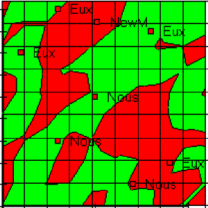 Fig.8 - Finding the optimal positioning of a new
product and estimating its market share
Companies can use spatial socio-demographic census information that is
available up to relatively small geographic areas like the census tracts
in order to infer information about their customers starting from not more
than a name and an address. They also can infer behavioural data from customer
purchase history to the smallest geographic units (census tracts). Using
this information they can obtain geographically consistent market segments.
These segments need not only to be homogeneous as to their socio-demographic
and behavioural characteristics but also as regards their geographic location.
Therefore we have developed several methods and algorithms to cluster the
smallest geographic areas adding spatial constraints. Geographically consistent
market segments obtained by these methods are used to orient the spatial
distribution policy of retail companies.
Fig.8 - Finding the optimal positioning of a new
product and estimating its market share
Companies can use spatial socio-demographic census information that is
available up to relatively small geographic areas like the census tracts
in order to infer information about their customers starting from not more
than a name and an address. They also can infer behavioural data from customer
purchase history to the smallest geographic units (census tracts). Using
this information they can obtain geographically consistent market segments.
These segments need not only to be homogeneous as to their socio-demographic
and behavioural characteristics but also as regards their geographic location.
Therefore we have developed several methods and algorithms to cluster the
smallest geographic areas adding spatial constraints. Geographically consistent
market segments obtained by these methods are used to orient the spatial
distribution policy of retail companies.
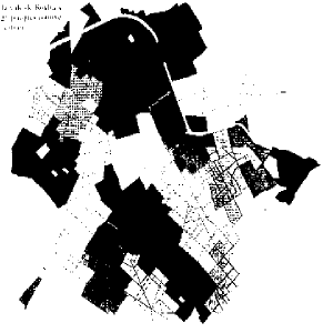
 Fig.9 - Spatially constrained versus not constrained
geographic market segments
Market areas or market territories computed for the same distribution point
or product (in the perceptual space) can differ depending on the method
used to compute them or on the time of the year in which they were computed.
Differences in market areas for the same offer at different times measure
the impact of marketing effort on one competitive position. We suggest
several methods to measure the congruence (or on the contrary the difference)
between two shapes of a market area and to test the significance of an
eventual difference.
Fig.9 - Spatially constrained versus not constrained
geographic market segments
Market areas or market territories computed for the same distribution point
or product (in the perceptual space) can differ depending on the method
used to compute them or on the time of the year in which they were computed.
Differences in market areas for the same offer at different times measure
the impact of marketing effort on one competitive position. We suggest
several methods to measure the congruence (or on the contrary the difference)
between two shapes of a market area and to test the significance of an
eventual difference.
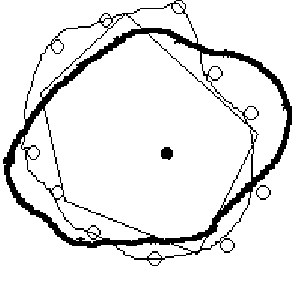 Fig.10 - Comparing different shapes of a market
area
Fig.10 - Comparing different shapes of a market
area